Anchoring Resilience: Ferries and the Future of Climate Adaptation in Lower Manhattan
By Armando Sullivan, AICP, Planner and Equity Lead

The Financial District and Seaport area of Lower Manhattan (“FiDi/Seaport”) is an employment, transportation, and cultural hub that provides vital connections for the city every day. The area is home to 290,000 jobs, 62,000 residents, and 17.7 million visitors per year. It is at increasing risk of coastal flooding in the coming decades—like what was seen during Superstorm Sandy in 2012—that could disrupt the utility of this hub and incapacitate much of its infrastructure. By the 2040s, tidal flooding due to sea level rise will begin to impact streets and critical infrastructure, and by 2100 this flooding will reach William Street, 5 blocks inland from the East River shoreline.
As part of the City’s overall Lower Manhattan Coastal Resilience framework, the New York City Economic Development Corporation (NYCEDC) developed the FiDi/Seaport Climate Resiliency Plan to adapt to future environmental conditions projected out to 2100. This is the most challenging section of Lower Manhattan to protect due to the proximity of the neighborhood’s buildings, the FDR Drive, and the waterfront.
Under the consultant team leadership of Arcadis, Sam Schwartz’s work zoomed into the area’s ferry systems, which are especially resilient due to their ability to operate in conditions in which other modes are disrupted. We holistically analyzed the waterfront to understand how ferry services could be consolidated to serve future conditions while maintaining service. New ferry facilities were analyzed in tandem with the master plan’s other considerations, including building flood defense infrastructure, building stormwater drainage infrastructure, ensuring universal accessibility, maintaining transportation networks, limiting impacts to the East River’s ecology, preserving existing public destinations, creating multi-level open spaces, and providing community serving uses.
The purpose of this project is to plan for future conditions to protect the neighborhood assets, infrastructure, and users, and ensure that the functionality and safety of this cultural hub is maintained. In order for this mitigation to preserve this existing access that residents rely on, it needs to achieve these goals:
replace existing waterfront public and open space amenities that would be disrupted
ensure universal access to the waterfront, including ferries and historic assets
site new drainage infrastructure to ensure the entire flood defense system works
protect historic and cultural assets
plan for new resilient ferry terminals and facilities with long term adaptability in mind
provide two levels of flood protection—for both coastal storms and daily tidal flooding

Existing ferry service in the FiDi/Seaport neighborhood encompasses 17 routes. It includes the Staten Island Ferry out of Whitehall Terminal which serves 25 million riders per year and 3,000 during peak hour; the NYC Ferry at Pier 11 serving 4 million riders per year with 1,200 peak hour riders; and the Governors Island Ferry out of the Battey Maritime Building serving 767,300 riders per year and 1,600 peak hour riders. The Battery Maritime Building and Pier 11 also support other regional ferry services, and Piers 15-17 are regularly used by visiting ships, excursion boats, and historic ships. In addition to mitigating sea level rise, we need to plan for ridership growth as these ferry landings will eventually be over capacity.
Our team developed ridership projections for no-growth, low-growth, and mid-growth scenarios to understand the different possibilities in ridership growth that would determine when these landings would reach capacity and need to be replaced or expanded. We projected possible future ridership scenarios, considering recent ridership growth, planned development like on Governors Island, and expected changes in future service.

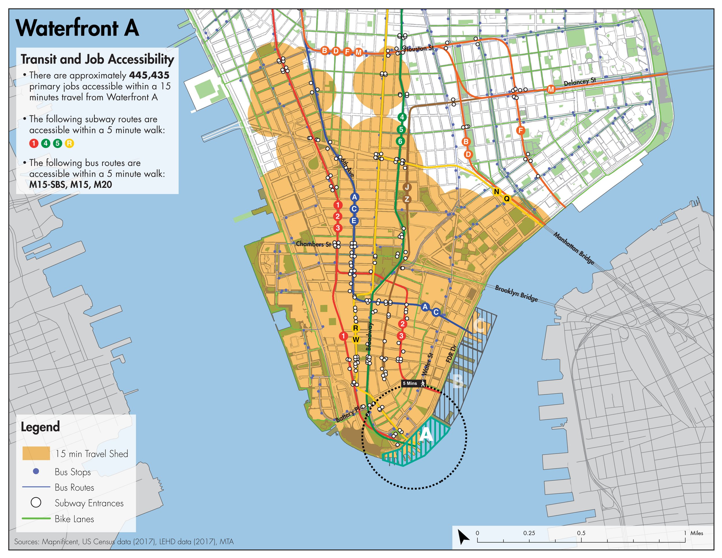
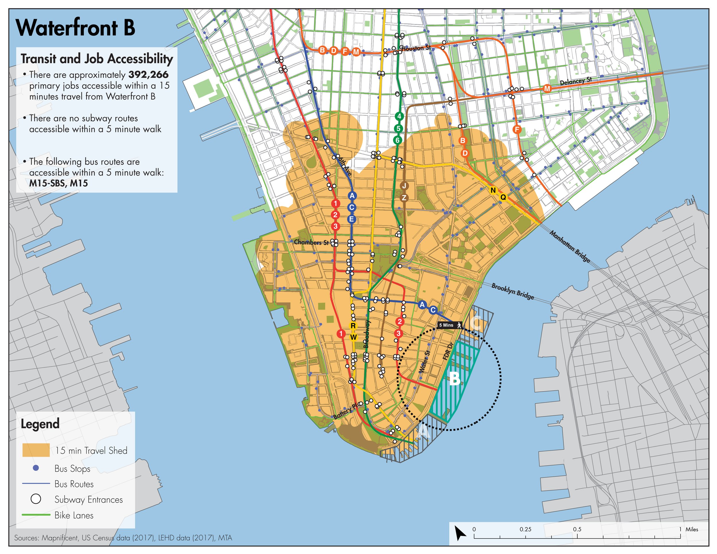
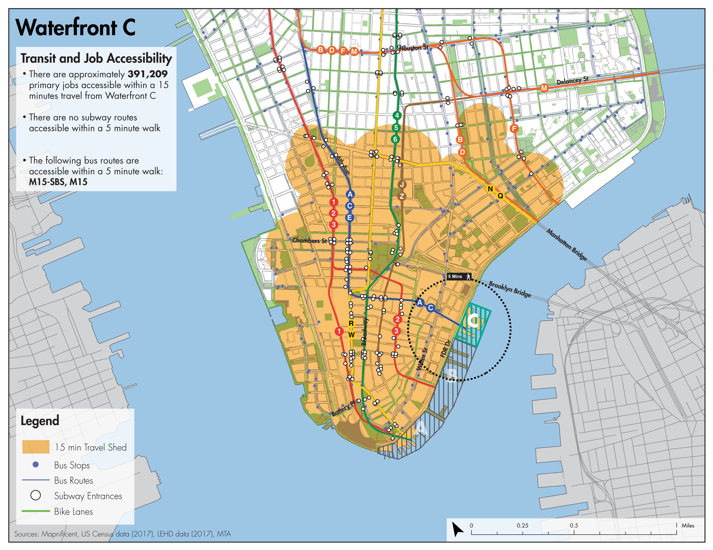
We worked with Matrix New World to study world-class ferry terminals globally to understand what is possible in terms of expanding service capacity and incorporating adaptability. Working with Matrix New World and ONE Architecture, we estimated the spatial requirements of ferry facilities based on ridership growth and improved passenger facilities. We assessed possibilities for relocating and/or consolidating ferry facilities to support coastal protection and provide more convenient access and transfers to ferry riders. One way we did this was by looking at relative access to transit and jobs for different locations; we developed transit and job accessibility profiles for three potential locations for a new resilient adaptable terminal at which some of these ferry services could be consolidated.

Sam Schwartz’s transportation access analysis and ridership projections, together with the larger team’s work, identifies critical investments that ensure the area can continue to serve as a hub while mitigating sea level rise impacts. Not only does this master plan protect the existing uses and users of the FiDi Seaport, it builds growth and adaptability into the waterfront.
Waterfront transit and job accessibility maps produced by Sam Schwartz. All other graphics sourced from the FiDi/Seaport Climate Resiliency Plan.