The Journey: Helping Lyft Create a Vision for Resilient Streets in Chicago
This post is part of our comprehensive look at how COVID-19 is reshaping the mobility landscape. For more original research, project work, and thought leadership from the Sam Schwartz team, visit the COVID-19 Response + Analysis center.
By Bree Mobley, Senior Transportation Engineer; Joe Iacobucci, West Coast General Manager + Director of New Mobility; Michael Groh, Senior Transit Planner; and Mike Flynn, Director of City Strategies.
Introduction
At Sam Schwartz, we have been fortunate to collaborate with clients and partners to make a compelling case for safe, equitable, sustainable transportation options both in response to the immediate challenges of COVID-19 and as part of the solution for cities’ long-term recovery.
For the foreseeable future, social distancing will remain a basic requirement of daily life. If this reality results in a prolonged drop in transit ridership (due to perception of risk if not actual risk, or due to a funding crisis leading to drastically reduced service) and more use of private vehicles, the ongoing return to daily activities could lead to severe traffic congestion: based on recent Streetlight data of Cook County, daily driving has returned to and exceeded pre-COVID 19 levels even while many people continue to work remotely or are unemployed. Increasing private vehicle use could mean a disastrous trajectory for greenhouse gas emissions and restarting the economy with travel habits that may be hard to reverse. Perhaps most importantly, getting around will become much harder for those without access to a personal automobile. Therefore, a vision for safely and affordably moving the greatest number of people in a physically distanced way is needed to allow a resumption of economic, educational, and social activity in our cities.
During the COVID-19 pandemic and mandates of social distancing, Lyft engaged with Sam Schwartz and Street Plans to assist with technical analysis and guidance for how to transform public space to ensure efficient, active, and equitable transportation options in urban areas. The concept, Resilient Streets, builds on the Open Streets pilots that have launched in cities around the world to connect people to opportunities and to minimize congestion and emissions as stay-at-home orders are lifted.
Simply put, Lyft is building on the momentum of slow streets/safe streets programs and making the case for expanding the programs and making these new facilities permanent through a concept called Resilient Streets.
Resilient Streets:
Provide dramatically safer and more comfortable routes to attract more trips by sustainable modes (walking, biking, scooting, transit)
Create better connectivity to jobs, transit, and bike/pedestrian routes
Facilitate affordable commuting options for everybody, and in particular, for vulnerable communities and essential workers
Reduce vehicle miles traveled (VMT) at a time when congestion is beginning to spike
Reduce greenhouse gas (GHG) emissions and support climate action goals
Our team supported Lyft in the effort to make the case for Resilient Streets through three example corridors in Chicago, New York City, and Washington, DC in order to identify (1) the impacts of reopening urban areas without new Resilient Streets and (2) the benefits of creating Resilient Streets in cities.
This blog post is the second in a series, focusing on converting the Division Street corridor in Chicago into a Resilient Street and our work creating a customized model in order to identify the need and benefits of the Resilient Streets.
Division Street, Chicago Case Study
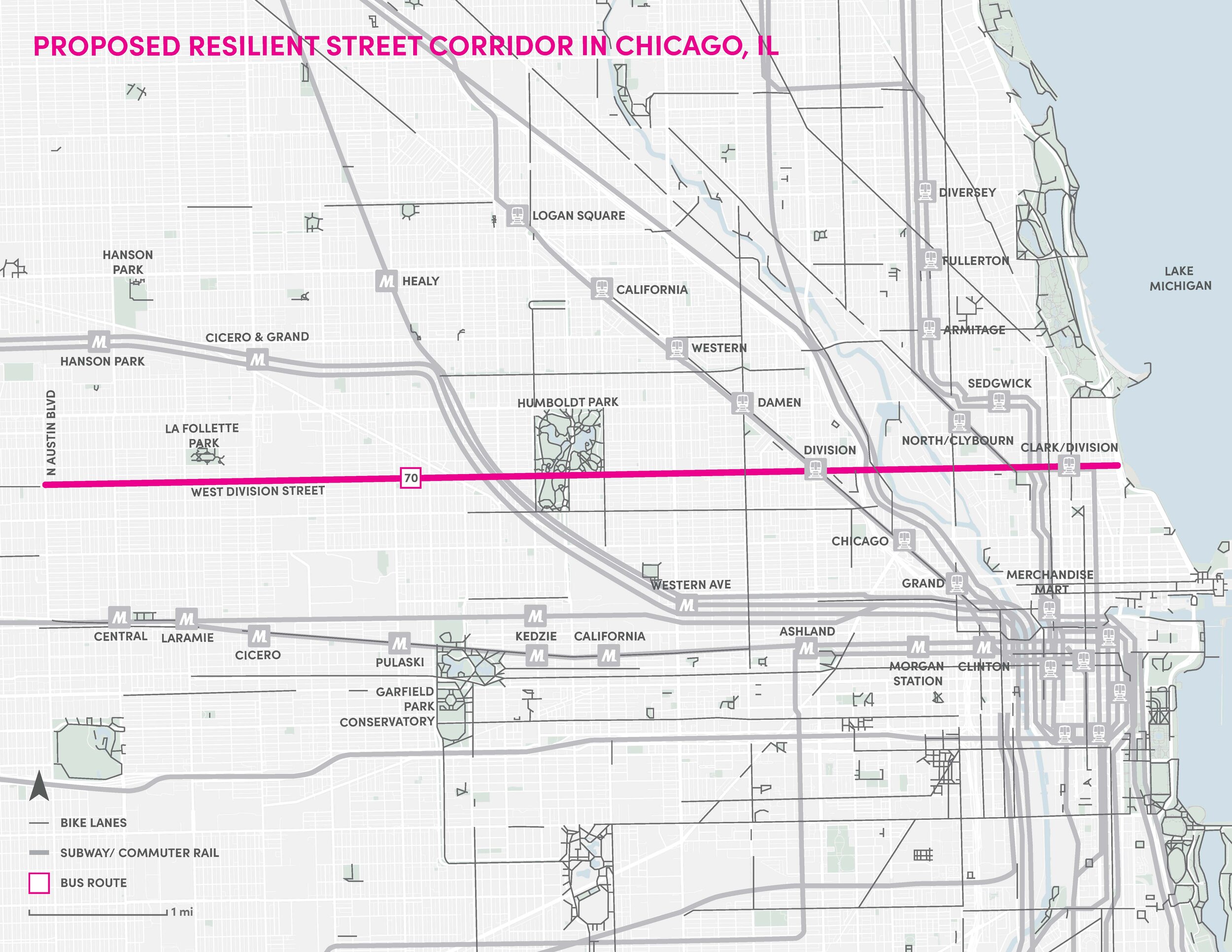
Proposed Resilient Street Corridor in Chicago
In Chicago, transit, biking, and walking move over one third of the city to jobs, education, and other destinations. During normal times, 36% of all commute trips in Chicago and 70% of commute trips to the Loop are made using a sustainable mode (transit, walk, and bike) every day. For commuters to the Loop, this amounts to 400,000 sustainable trips each day.
Sam Schwartz looked at the study area in Chicago’s West Side and performed a series of analyses to identify the impacts of the pandemic on commuting and how travel choices have changed. As a first step to quantifying the impacts of Resilient Streets on Division Street, our team researched existing, pre-COVID-19 travel trends to understand and estimate the total number of people traveling on sustainable modes under typical conditions on selected corridors.
At a high-level, the model combined pre-COVID-19 travel trends with global research producing two scenarios that model transit commuting behavior changes and mode shifts due to COVID-19. The model assumes the continuation of preference for part of the population to avoid crowded subways or buses as the City returns to pre-COVID-19 activity levels. This was coupled with factors that accommodate an increase in teleworking, flexible work schedules, and continued higher-than-normal unemployment. Assumptions of mode shift also included greater adoption of electric-assist bikes (e-bikes) to make longer trips by bicycle possible for a greater number of people and the creation of “bicycle superhighway” treatments to prioritize and speed-up micromobility trips in comparison to other modes.
The following specific elements were included as part of this analysis:
1. Two factors were considered to determine COVID-19 travel preferences:
Transit capacity reduction factor (range 50% - 100%) - Train and bus capacity recommended by operators to maintain social distancing
Transit desire factor (50% - 80%) - Portion of commuters who feel comfortable taking transit considering perceived virus risk
2. Travel time for commute trips within 1-mile radius of the proposed resilient street corridor was used as a proxy for trip distance. Trip distance was used to guide mode choice.
3. Displaced transit commuter volumes were re-assigned to bicycle, e-bike, and pedestrian trips based on trip distance, peer city mode splits, and proposed resilient streets facilities. Commute trips not accounted for in the sustainable modes listed above were considered to work from home, commute off-peak, or switch to auto trips.
4. Peak hour volumes were adjusted using local commute trends to represent daily volumes.
Primary Results
No Action Scenario
An estimated 7,000 morning transit commuters on and nearby Division Street will be looking for another option as Chicago reopens. If no action is taken and streets remain as they are today, approximately only 19% of displaced transit riders (1,700) would walk or bike. As a result, thousands of single occupancy vehicle (SOV) trips could be added to Chicago streets.
Resilient Streets Scenario:


Before and After: Division Street. Developed by Street Plans. Note: this image is a proposed rendering and not a final design. It is merely illustrative and is not intended to replace the full community engagement process.
An estimated 7,000 morning transit commuters on and nearby Division Street will be looking for another option as Chicago reopens. Building a Resilient Streets Corridor on Division Street would:
Accommodate over 14,000 sustainable trips daily, including:
4,000 bike trips daily
5,000 E-bike trips daily
4,700 walk trips daily
Save 38,000 VMT daily
Remove 4,000 metric tons of C02e annually
People and Community Impacts
Using available demographic and commute data for the areas surrounding the corridor, we conducted an equity analysis to estimate the project’s benefits by income, race, and job classification including consideration of the additional benefit that such socially-distanced transportation may provide to those who cannot work remotely and must report to work in person. The end-result of our analysis provided the specific concepts and backup calculations to quantify the impacts and distribution of the improvements.
The figure below shows the breakdown of zero-car households that would most benefit from Resilient Streets.

Division Street in Chicago, running from Lake Michigan to the edge of the city, traverses vibrant, historical neighborhoods such as Austin, Ukrainian Village, and Humboldt Park. The proposed Resilient Street has potential to impact a racially diverse area: 25% of the population is Black, 5% is Asian, and 24% of the population ethnically identify as Hispanic. Moreover, in the area within 1 mile of the proposed Resilient Street, 71% of homes have access to a personal vehicle while 44% of workers rely on transit to commute, which puts the area at high risk of choosing driving in COVID-19 conditions and degrading traffic conditions and safety for transit, biking, and walking.
Finally, over 100,000 people in the study area work in essential industries such as education, healthcare, warehousing, transportation, and utilities, which represents 62% of total workers.
Conclusion
There are dozens of examples of cities across the world that are adjusting their streets to better suit their citizens needs amid this global pandemic. With the COVID-19 virus disrupting traditional travel patterns and commuting peaks, Resilient Streets can be the answer to diversifying and maintaining travel while reducing dependence on low capacity and emissions-heavy autos.
Our project team included Bree Mobley, Henry Hammel, Joe Iacobucci, Kate Sargent, Michael Groh, Mike Flynn, Po Sun, with advisory from Richard Retting and Stacey Meekins.
The most important transportation stories, direct to your inbox. Subscribe to TransCentral today.